WT1 Cam 9
Posted: Tue Oct 07, 2014 3:52 am
Hi everyone! Thank you Ryan and everybody in this forum because you did recommend me the youtube channel of Ryan. He's really the best IELTS teacher on the internet and his work really helps a lot of international students like me to study IELTS better 
Now this is my first try after watching Ryan's videos. I've just finished this WT1 from Cam 9. I saw the key in the book already and I know my below essay is longer than needed. However, I just wish somebody here can comment on its structure. You know, the key goes from the first map, then to the second map, while I goes from "housing" to "transportation" and show the differences between both maps from the start.
Thank you a lot!
Here's my essay:
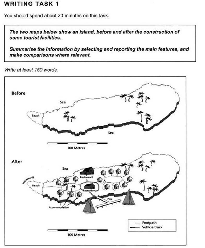
The maps show how the island change after the construction of tourist facilities. As can be seen, the island has been utilized more efficiently than before construction, with the aim of better tourism services.
Firstly, there is a big change in house construction. Before facilitated, the island was like a forgotten area where the only thing can be seen was trees. After the construction, the large wasted space was filled with restaurant, reception and accommodation area. Accommodated houses were centralized into two areas, one of which was built around trees. Between these two areas stand the restaurant and the reception house. The sea around was also utilized as a swimming area to the west and a bay to the south of the island were built. This means the tourists now can both enjoy the nature in the island and relax themselves by some coastal recreation when come to visit this small land.
Secondly, the transportation was also improved after construction. As the maps show clearly, while before facilitated the island has no paths to go, after facilitated it has both footpaths and vehicle tracks. The footpaths were skilfully constructed in the accommodation areas; they surely help to connect the houses in a circle as well as to link the beach, where tourists can swim. Around the reception house, a vehicle track was also built. This track connects the reception house to the restaurant in the north and the pier in the south. Tourists now can find the island much more convenient to get some rest.
The task is attached herewith.
Thanks for your help!
Now this is my first try after watching Ryan's videos. I've just finished this WT1 from Cam 9. I saw the key in the book already and I know my below essay is longer than needed. However, I just wish somebody here can comment on its structure. You know, the key goes from the first map, then to the second map, while I goes from "housing" to "transportation" and show the differences between both maps from the start.
Thank you a lot!
Here's my essay:
The maps show how the island change after the construction of tourist facilities. As can be seen, the island has been utilized more efficiently than before construction, with the aim of better tourism services.
Firstly, there is a big change in house construction. Before facilitated, the island was like a forgotten area where the only thing can be seen was trees. After the construction, the large wasted space was filled with restaurant, reception and accommodation area. Accommodated houses were centralized into two areas, one of which was built around trees. Between these two areas stand the restaurant and the reception house. The sea around was also utilized as a swimming area to the west and a bay to the south of the island were built. This means the tourists now can both enjoy the nature in the island and relax themselves by some coastal recreation when come to visit this small land.
Secondly, the transportation was also improved after construction. As the maps show clearly, while before facilitated the island has no paths to go, after facilitated it has both footpaths and vehicle tracks. The footpaths were skilfully constructed in the accommodation areas; they surely help to connect the houses in a circle as well as to link the beach, where tourists can swim. Around the reception house, a vehicle track was also built. This track connects the reception house to the restaurant in the north and the pier in the south. Tourists now can find the island much more convenient to get some rest.
The task is attached herewith.
Thanks for your help!